The pressure is on to finish up this project before the end of summer, last week was a tough one for me to get out and do a firehouse run, so hopefully this week I should be able to get most of the remainder in. It was a beautiful morning to head towards Westfield and do some of the firehouses from there to the west. There are three firehouses in Westfield, however, on this run I only shot the first two, as we were running out of time today. Hopefully tomorrow I will be able to get the last two towns on that route, as well as the third Westfield one I had to skip today. Regardless, the first stop was at the firehouse on Southampton Road, which all the locals know as Route 10, College Highway. This one is just north of the entrance to the Mass Pike in Westfield.


It was then time to backtrack a little bit from here, so we could head towards the town of Blandford, where I happily remembered my "shortcut" route to school down Franklin Street and Russell Road. Since I haven't driven that way in over a decade, it was pretty cool to see that many of the landmarks and business along the way were still as I remembered them. We drove the mountain to Blandford to the firehouse there on Main Street, with my car engine whining pitifully the entire way.

After Blandford, the next stop was to the town of Russell, where my borrowed GPS wanted me to go down a dirt road for 3 miles to get there. I was not thrilled about dirt roads, so I backtracked down the mountain and we took a route a little longer but saved me from white knuckling the steering wheel. The firehouse in Russell is located on Main Street in town.

Now here is where it gets interesting.
The town library also shares the building with the firehouse. I will bet that the firefighters have no shortage of books to read when they are on duty and waiting for a call- do you think?
There is also a great memorial out in front of the firehouse here.

 |
| I remember this fire distinctly I could smell the smoke from it during my classes in Westfield |
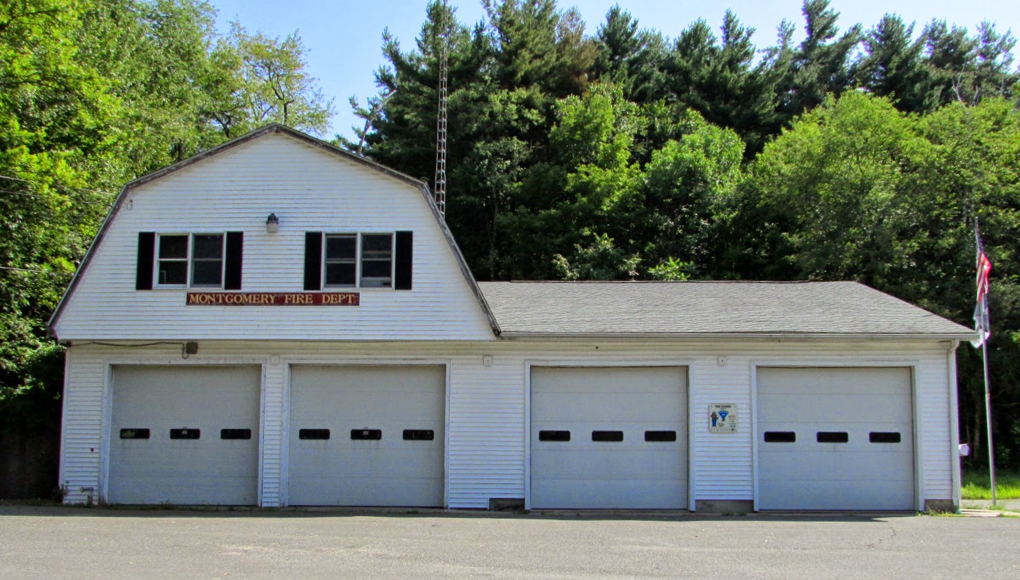
After the town of Russell, it was time to head towards Montgomery and the firehouse on Main Road. Luckily no dirt roads this time, but of course lots of hills to travel up and down.
Turning back towards Huntington, it was time to head northwest towards Chester. The firehouse is located directly on Route 20, and of course we had to travel by the dam again. Did we stop since we missed it last time? Of course not. Another opportunity we passed up again. Actually, good thing we didn't as we lost time later on in the run. More on that in a minute, here is the Chester firehouse below.


I also got my first truck of the day here, parked on the side of the firehouse. My apologies to the neighbors next door for your little dogs barking nonstop while I was shooting photos of the truck. They are brave indeed for defending their territory through their fence. My ears are still ringing from their yipping.

After Chester, it was time to go to Becket. Finding the two firehouses there made it offically the town from hell for us. I had two addresses from multiple sources, one on Wells Road and one on Main Street. We spent an extra half an hour determining that neither address was accurate. I think actually that the Wells Road address is the home of the fire CHIEF and not the actual station. Luckily, one of the firehouses is located just below Wells Road, along Jacobs Ladder Trail, so at first we figured that the address was just a little off.

We headed back down the trail to head to the Main Street firehouse, and soon determined that there was NO firehouse to be found along it. There was a town hall, post office, DPW, etc, but no firehouse. So brilliant thinkers that we were, we said hmmm, the second one must be at the Wells Road location. Back up the trail we went, past the first firehouse onto Wells road. When the GPS brought us to a resident's house, we realized that must be owned by the chief. So back down the trail we went to travel further down the Main Street to find the firehouse. Finally having the brains to google more information, we got the correct address of the second station, which was kind of along the Main Street, but about another eight miles down the road. But we made it!

Aggravated at the lost time, it was time to push on to the next town on the route, Otis. I was not amused when the GPS sent us back UP Jacobs Ladder Trail to get to that town. (In case you weren't keeping track, that now made it THREE times we had to drive by the first Becket station.) Regardless, we made it to Otis, and I was thrilled when we reached this station on South Main Road.


In the southwest corner of the firehouse property they have done a great job of making a small walkway and path with some fantastic carved benches and memorials.


The detail work on these benches was amazing. I could have happily stayed longer just looking at all the intricate carvings.
Unfortunately, we were pressed for time so it was off to the next town on the list, Sandisfield. Of course, the GPS wanted to take me down a side road, where after a couple of miles, it directed me to turn left onto you guessed it, another dirt road for the next three miles. I had luck with the last dirt road on the list, only causing us to lose a few minutes with a detour by avoiding it, so I figured, lets avoid it again. Right? Well it was a good idea at the time.
We continued on another few miles, seeing few houses and signs of civilization, and I was happy that the new direction the GPS was directing us to go was only going to cost us about an extra ten minutes or so. Until, of course, the next turn it directed me to make was onto another dirt road. With Bill laughing at me, and asking me how I have managed to live in New England for so long without driving on dirt roads, I said a few choice words not to repeat here, and gunned the car down the road. Now, The GPS said .8 miles so I figured, how bad could it be? It was actually just fine until we got to the end and the next turn the GPS directed us to was down yet another dirt road.
For another 3 miles.
I was screaming inside my head most of the way, especially when we hit the parts that I shudder now to think about where the road had washed out and it was nothing but holes, large rocks, and craters. The best part was when we finally reached a house and some signs of civilization. As the road suddenly evened out a bit and looked smoother, we turned our heads around to see the sign on the road we had just come from, saying "Road Closed". Mental note to self-make sure GPS is programmed to only direct us on routes that are main roads. We continued along the blessedly paved road for about another five minutes or so, and I had to work really hard to refrain from smacking Bill when he pointed out the side road that we were passing at one point along the road was where the first dirt road would have brought us out to if we had taken it in the first place. I have since decided that those dirt roads were definitely more aggravating than the Becket firehouses were.
We finally reached the first Sandisfield firehouse, located on Sandisfield Road.

At least there was a truck outside this one for all my efforts at getting to this station from Otis.

Ten minutes or so of driving later
, we reached the second station, located on Main Street.

An interesting thing about this firehouse, it is attached to another building in town, the American Legion. Somehow I don't think they are reading as many books here like they do in the town of Russell.
The next stop was in the town of Tolland, and we wound up driving in the wrong direction for about four miles, which we realized when we hit the Connecticut state line. For those not familiar with this area, there is indeed a Tolland CT, which the stupid GPS had decided we wanted to go to instead of the one here in this particular state. (I had thought it was odd we were driving away from Route 57-but as long as it was a paved road, at that point I didn't care)
We reached the town after going up an incredibly steep hill, boy was my car working overtime today. The station here is along Route 57, technically on West Granville Road.

Photographing this beautiful new firehouse made the hills worth it!
Continuing east on Route 57, and discussing why the Heinz 57 ketchup brand got the name, we reached the Granville firehouse on Main Road, located right behind the town hall offices.

There were a couple of trucks outside near the front of town hall, but at that point, we were desperately pressed for time, so I didn't take the extra minutes to photograph them. Since we had to continue east on Route 57 to get Bill back home for a meeting, luckily we were able to also hit the firehouse in Southwick along the way.

I would have preferred not to shoot the firehouse while they were making repairs to the outside, but at that point of the run, I was taking what I could get. When I return this week to get the third Westfield firehouse, hopefully I can get a clearer shot of this one. We made it back to Easthampton about twenty minutes late, but got a lot more done today than I thought, considering our delays of the morning.


