Today was a beautiful day to finish up the lower southwest corner of the state, and I was driving solo on this trip. I headed up the Mass Turnpike to the first stop in the town of Lee, about a 45 minute drive from the interstate. I had two listings for Lee, both within the same block, but discovered when I arrived that there was only one firehouse in town, on Main Street. (FYI-to google maps-there is no station on Railroad Street!) I was pleased with this first stop as the firehouse there I thought looked particularly interesting.

 |
| Another firehouse mailbox! |
Just behind and next door to the firehouse is the town EMS location, and across the street there were two pretty neat looking fire trucks from other towns parked there as well. There is a second station in South Lee, but more on that later.

 |
| Literally a brush truck! Note the apparatus in the rear of Forest 1 |
But those weren't the only neat vehicles in Lee. Below see two of the other trucks parked across the street from the EMS services in town.


The next stop had me heading northwest to the town of Lenox, an area I have become pretty familiar with in the last year or so, after all, Ventfort Hall is just down the street. I was easily able to find the firehouse there pretty quickly on Walker Street. This firehouse is located behind the town office building, and for some reason, the downtown area was really busy. Parking was at a premium today.

After Lenox, it was off to the town of Hancock, and I was dismayed that I had to go north through part of Pittsfield (again!) to get to the south station. The south station is located on Route 20, and is just a half mile west of the Hancock Shaker Village. Judging from the amount of vehicles in the parking lot there, definitely a high spot on the tourist attraction list. I didn't have much time to sightsee the area today, so I had to pass on a stop there. Hancock also has a north fire station, located more towards the towns of New Ashford and Adams, which I had taken photos of on a previous visit to the area on Sept 4th.
 |
| Hancock Station 1- Hancock Road |
 |
| Hancock Station 2-Route 20, Lebanon Mt Road |
After the second station, it was time to head southbound a bit to the town of Richmond, where the firehouse is located on a newer road, aptly named Firehouse Lane. Luckily, it was visible right off the main route into town, as my borrowed GPS didn't have that particular road listed. This station is next to other town department services, and is a great looking building, especially in the setting sun.

The town of West Stockbridge was next on the list, and the firehouse is located right on Albany Road.

Continuing southeast, the town of Stockbridge came along next, where the firehouse is located on East Street.

I absolutely loved this firehouse. It has a great long driveway leading up a slope to it, with old wrought iron gates and cement pillars at the entrance. Even better, plenty of places for me to park at this firehouse!


The firehouse here also has a great memorial on the front side of the building.
The next town, Great Barrington, posed quite a challenge for me. I lost a lot of time trying to get from one firehouse to another, as the town has two stations. I still have no idea what was going on along Main Street today, but it took me about a half an hour to travel about 2 miles. Ridiculousness. The first firehouse is located on State Road. And may I state that this is a positively HUGE firehouse.

It doesn't look that large from the above shot, but to give you an idea of perspective, here is a shot from just the front bay doors below.


I won't even mention that there are side and back bay doors as well at this firehouse! I especially liked the garden memorial area in the front that utilized the old firehose wheel apparatus. If you enter into the far right of the building, you can view a real antique fire engine. Unfortunately I didn't get a chance to shoot photos of that one-you will have to go check it out on your own. However, in the rear of the firehouse I did come across one more piece of equipment, that unfortunately in this day and age is needed.
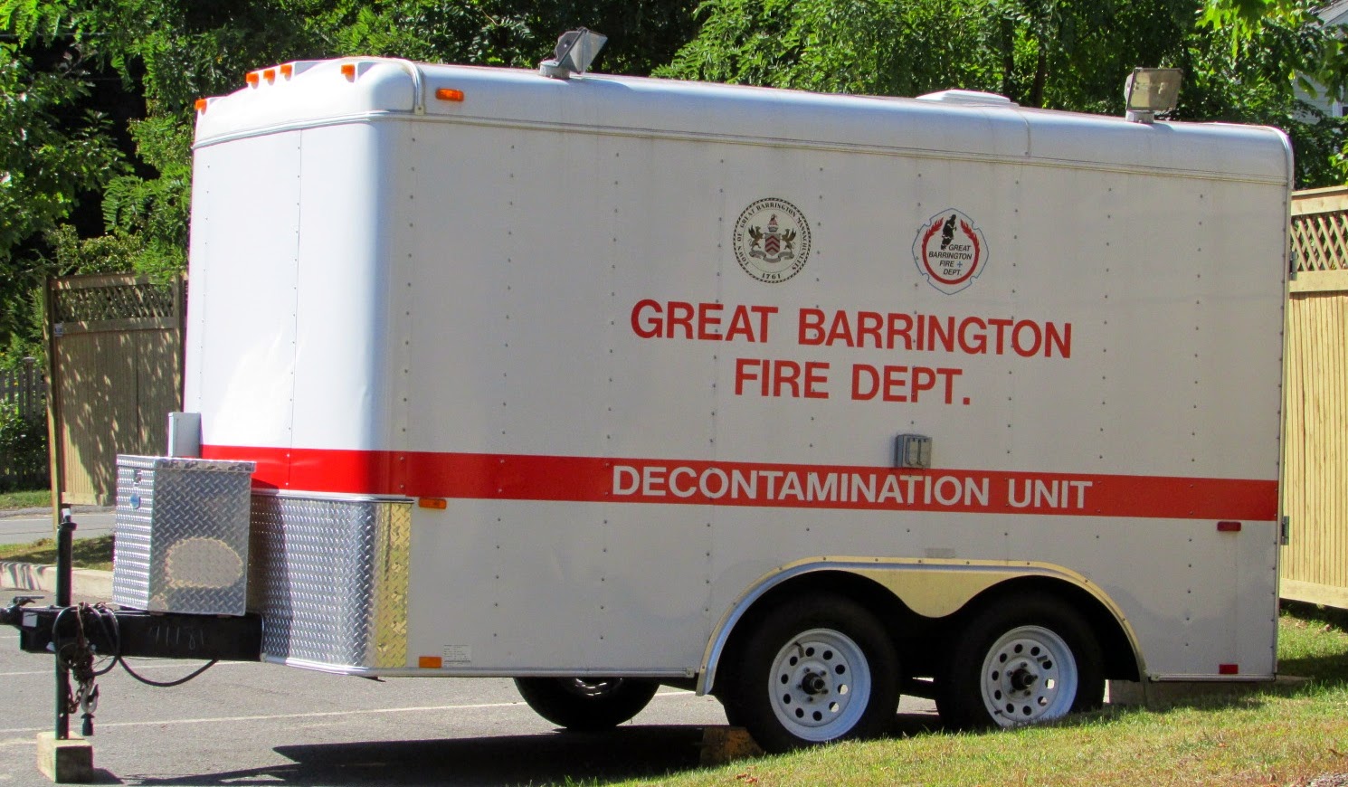
The second firehouse is on Castle Street, and right off the main intersection of downtown across from the town hall offices.
This firehouse was the worst to get to with the traffic this afternoon. Unfortunately all the side streets I could have taken instead to get to it were all dead ends, so I suffered through some more stop and go traffic on the way. But I made it!


After those two were checked off the list, it was time to travel a little bit more west towards the border towards New York, and get to the town of Alford. The station here is located on North Egremont Road.


For the record, I would just like to make it perfectly clear to anyone who cares about accuracy, every reference I had for this firehouse stated it was at 59 North Egremont Road. As you can see from the address on the firehouse signpost. Those references were WRONG! 59 does not mean 86!
Where #59 should be-there are woods!
Continuing south from Alford, the next stop was to the town of Egremont. I discovered here that there are TWO firehouses, where I only had one listed. Luckily I drove right by the first one by happy accident, so I was able to stop and get some shots of this first station, located next to the town police department. You can see from the front view of the building why I drove by and almost missed this one.


If it wasn't for the sign out front, I would have thought it was just a residental address. Wouldn't you have?
Below is a side view of the firehouse


The second firehouse is located right along Main Street.
Helpful hint for anyone traveling out that way, the speed
limit is 35mph and the town police have a great parking spot in front of the second firehouse to watch you travel by, hopefully doing the speed limit!

It was time to head south to the next stop in the town of Sheffield. If you travel along Sheffield road to head to where the firehouse is located, you pass by a little bit of American history. (Not that all of New England isn't central to quite a bit of our country's early history!)
Just where the Appalachian trail crosses Sheffield Road, there is a marker to note where the last battle of Shay's Rebellion was fought. ( If you don't know what this was all about-look it up in your history textbooks) The marker itself IS crooked, so no error here in photographing it on my part.

After that quick stop on the edge of a cornfield for the marker, I continued heading down towards the back end of Depot Square in Sheffield. The sun was starting to set more at this point, so I wasn't too happy with the shadows cast on the firehouse from the surrounding trees. But I did the best that I could with what I had to work with. I was kicking myself for not starting this run earlier in the day. Somehow I think my students wouldn't have minded me cancelling classes on a Friday for this.


There is a small memorial here in the front
corner of the Sheffield firehouse as well.
Continuing Eastbound, the New Marlborough firehouse was next on the list, but is located in the town of Southfield. At least the GPS was able to get me there without any trouble-a first for the day today on that account!

This location is pretty interesting, as there is a newer firehouse right next to the older volunteer firehouse. I would love to find out the story about that one at some point.

However, I spoke too soon on the GPS not failing me. The next town on the list was Monterey. The GPS did a fine job getting me on the road towards the firehouse on Main Road, for the first few miles. If you have read any of the earlier posts in this blog, it isn't hard to figure out what is coming up next in this narrative.
DDR alert!
Yep, a Damn Dirt Road.
I sighed when I saw the line on the route begin to go from wide to small on the GPS screen. I also began saying a bunch of other things after that however, that I won't repeat for my readers here.
For 3.7 miles.
The first mile and a half was easy as pie though. The road was wide and well graded, and populated with houses the entire way. I thought, not too bad if the rest of the way is like this. I hit mile 2 and it began to be not so much fun. I should have known when the road narrowed and led into a more forested area that it would get hairy. Sorry to the guy in the truck that was coming the other way at that point, I just wasn't going to hug the ditch. Not in my vehicle which has no capability of getting unstuck if I drove it into said ditch.
You were driving a truck after all-you can get yourself unstuck no problem, unlike little old me in a Camry. Right? All good.
After another half a mile, I crossed a real, genuine, man-made steel bridge, which made me feel better about this particular route. Civilization at its finest! One mile left to go and I was in the home stretch. However, the next mile got worse. I bottomed out a couple of times along the rocks, but it was too late to turn back, never mind that there was no room to turn back at this point in the game.The local wildlife had to have heard me coming, since I had the windows down and was screaming out loud at the stupid road, stupid hills, stupid trees, stupid rocks, stupid woods, and everything in my path that I determined to be stupid. I did find quite a bit of things to yell at for that last mile.

Pretty good looking sign out in front of the firehouse by the way!

The last stop, or so I thought anyway, of the day was at the town of Tyringham. Easy to get to on the town's Main Road, I was able to shoot photos of this firehouse without too much interference from the setting sun. You know you're in a hilltown though when across the street are three octogenerians enjoying the afternoon sitting outside on their front porch. I probably gave them some excitement in their day by saying hello to them. They were certainly having fun wondering what I was doing with my camera at the firehouse.

It was time to head back north towards Lee so I could jump back on the Turnpike to head east towards home. Unfortunately, there was a nice road detour that took me about 3 miles out of my way to get around. Since the signs said "Road Closed-local traffic only", I figured not to press my luck on more bad roads and took the marked detour-which wasn't a DDR!. Luckily for me I took the detour, as when I came out to the main road to continue on, I happened to look towards my left and saw......
A shiny red engine out in front of a firehouse!
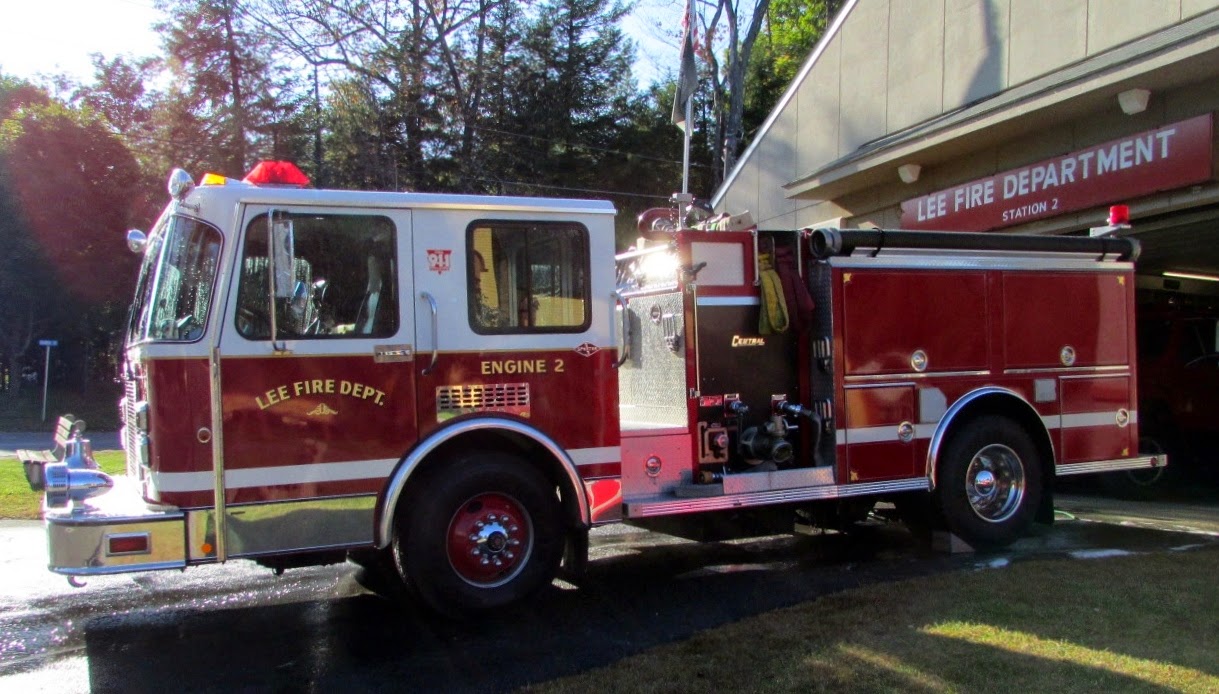
Of course, a firehouse that didn't show up on my original route listings. So I hung a left, and discovered I was at the second Lee station, technically in South Lee. Hmmm....another station for me to tell the state directory listings they omitted. Makes me wonder if I missed any more along the way. Some of the crew were out washing the trucks, so you have firefighters in action on this photo. Well, the daughter of one of the firefighters anyway. She was doing a great job!

The truck all spiffed up and drying in the sun
One more hour to go to travel towards home, and I was exhausted from the five hours I had already logged in. Another short run to the two firehouses in my hometown, and hopefully a trip to the base at Barnes in Westfield, and this project is almost completed. Stay tuned!


